
Music City Skyway
Why Aerial Gondolas Should Be Nashville’s Next Transit Frontier
By Kaitlin Dastugue, Chief Operating Officer, and Eric Hoke, Design Director
10 min read: Go on a vibe-setting journey with Kaitlin as she describes a vision for Nashville Gondolas inspired by the Roosevelt Island Tramway. Eric advances this thought to the Nashville context.
View looking east towards TPAC on the East Bank from Downtown, showing gondolas crossing the Cumberland River
(Original rendering from BIG, William Rawn Associates, and Hastings Architecture; Design Center Photoshop collage overlay; Google Gemini: architectural watercolor overlay)
For our next innovative transportation idea, let's look up. Kaitlin’s photo of her morning excursion
Last spring, I was in New York celebrating a friend's 40th birthday. We both happened to wake up before dawn that morning, so I asked if she wanted to head into the city to catch the sunrise somewhere. She enthusiastically replied, "I have the perfect idea."
We watched the sunrise from 250 feet above the East River aboard the Roosevelt Island Tramway. It was simply magic. As we floated across the river alongside commuters heading to work, I was jealous that my fellow passengers got to have this experience every day. My friend, a lifelong Nashvillian, turned to me and said, “Wouldn’t it be amazing if we had something like this in Nashville?”
Weeks later, I sat in on a presentation from UTK Architecture students who were studying our riverfront.
Analysis from Ryan Barnes, UTK College of Architecture and Design Summer 2026 Nashville Urban Design Studio
The Civic Design Center hosts the University of Tennessee College of Architecture and Design summer studio annually. They start the studio with a data analytics portion that leads to a micro project to support their designs. A student highlighted the idea that in order to better connect people to the Cumberland River they must be able to actually see it, but there are not many opportunities to do so due to the elevation of most public areas along the river. The main takeaway was: Our river is very hard to experience at street level. To experience our river, you often need to be on it or above it.
So dream with us: what if we had a gondola system that allowed you to experience our city and its natural features, from above? It could serve as both transportation and recreation, a practical way to move people while giving residents and visitors a new way to experience Nashville. Cities around the world, most recently Paris, are increasingly incorporating aerial trams and gondolas into their transportation networks because they're efficient, sustainable, and relatively inexpensive to build. But they also offer something we don't talk about enough when discussing how we move around our city: joy.
While this idea isn’t new (hats off to former Councilmember Colby Sledge), I do think it’s the right time to give it the serious consideration it deserves. As we plan to concentrate more large events and venues downtown and on the East Bank, giving folks as many avenues to CHYM (or choose-how-to-get-the-heck-out-of-downtown’s-gridlock-at-10pm-on-a-Saturday-night) should be top of mind for our policymakers and planners.
Design Director Eric Hoke discusses ideas around the creation of how an urban gondola system could look in Nashville. As Nashville continues its rapid growth, moving people efficiently, sustainably, and equitably across Davidson County requires looking beyond conventional road networks.
Aerial Map Of Gondola System
(Base map: Bing Maps)
Gondola System Map of La Paz, Bolivia
(reddit/TransitDiagrams: User: fiftythreestudio)
Gondolas are no longer just alpine ski lifts or novelty tourist rides. Cable transit demonstrations in cities like La Paz, Bolivia have constructed extensive aerial ropeway networks (Mi Teleférico) that function like a full-scale metro system on a transit map.
At the Civic Design Center, our Guiding Principles have long emphasized designing a walkable, human-scaled city that honors its natural landscape. A central pillar of our vision is reorienting Nashville toward the Cumberland River, transforming it from a physical barrier into a unifying feature. Gondola lines naturally span over water without requiring expensive new bridge deck construction. Suspended above the water, gondolas offer views of the river and skyline, turning daily commutes into engaging civic experiences while physically bridging east-west and north-south divides across the Cumberland.
Historic Nashville Street Car Map
(Map from Plan Of Nashville: Avenues to a Great City)
Nashville has a rich history of innovative transit reshaping growth. In the late 19th and early 20th centuries, Nashville’s streetcar network connected residents to suburban parks like Shelby Park, Fort Negley, Centennial Park, and Bordeaux, which created equitable access between green spaces and economic centers. Aerial gondolas could represent the modern evolution of that vision, connecting parks, cultural hubs, and job centers without taking up precious surface road space.
Unlike light rail or streetcars, aerial gondolas operate in an exclusive grade-separated right-of-way that leaves ground-level street capacity completely intact. This is particularly crucial for Nashville, where tight urban streets are heavily pressed for space across competing modes.
Reliable, Frequent, and High-Capacity Travel
Gondolas stand out when compared to traditional transportation in terms of reliability, frequency of trips, and consistent speed. Because cabins operate elevated in the air, they experience no delays from traffic lights or road congestion, allowing passengers to rely on optimum travel speeds. System frequency can be exceptional. A single gondola network can move the equivalent of one full bus load of people every minute.
Tricable Cabin Photo
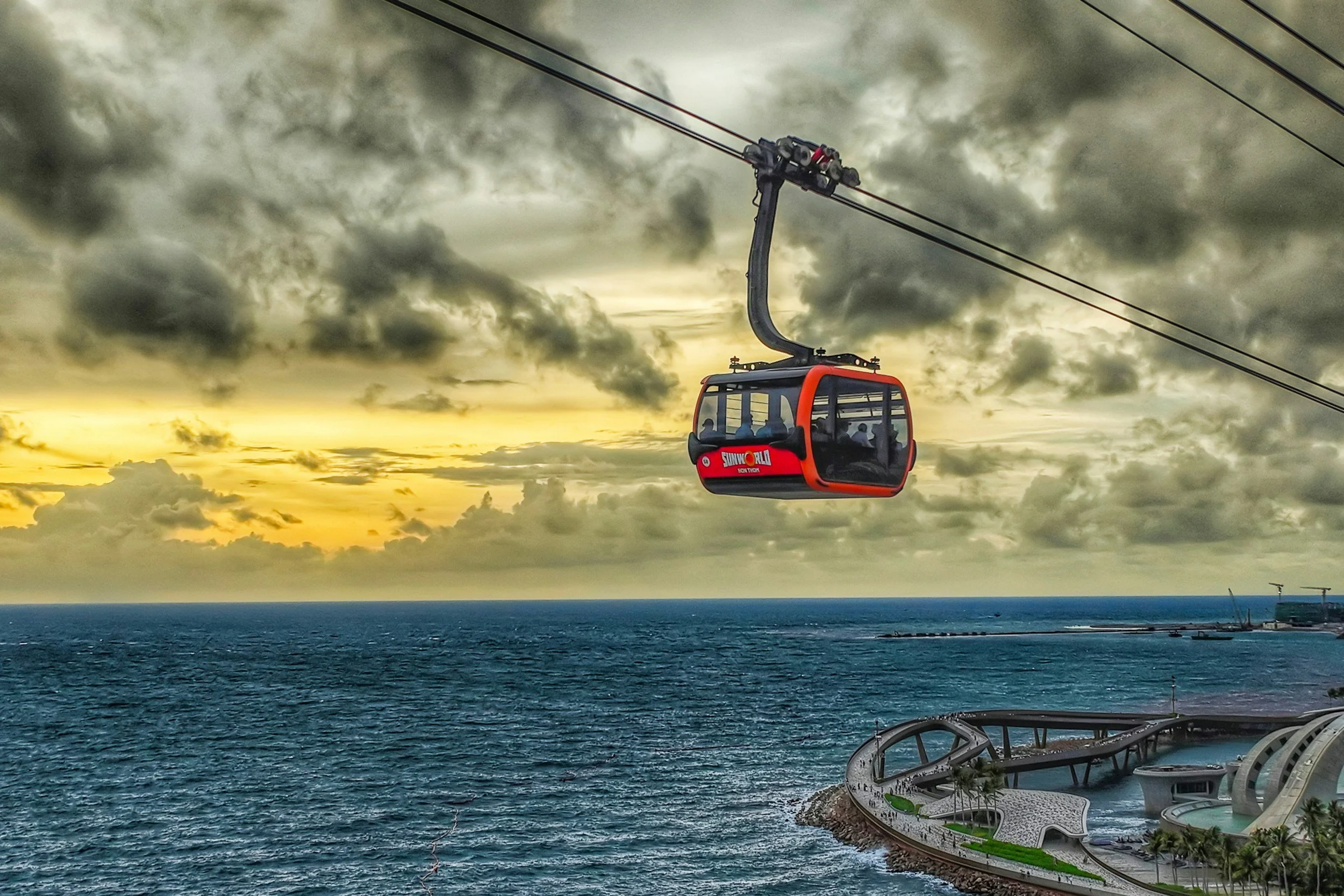
Advanced 3S tricable systems utilize two track ropes and one haul rope, allowing cabins to carry over 30 passengers per car while providing extreme structural stability during strong winds. Unlike fixed aerial tramways or historic cable cars, modern gondola cabins detach from the continuous main loop cable upon entering a station. This slows the cabins down dramatically to allow seamless, level ADA-accessible boarding while the rest of the line continues moving at full speed.
From a climate perspective, gondolas offer a powerful alternative to electric road vehicles. While gondolas easily run on 100% renewable grid electricity, they operate completely battery-free. By avoiding massive battery packs, gondola systems eliminate the need for lithium, cobalt, and other heavy minerals sourced from environmentally damaging mines—directly addressing a major sustainability challenge associated with widespread electric vehicle adoption. Furthermore, because the infrastructure is overhead, gondolas do not take away precious street space or lane capacity from pedestrians, cyclists, or surface transit options.
The system operates quietly on central electric motors located at terminal stations. To address community concerns near residential corridors, modern cabin designs incorporate electrochromic glass that automatically frosts over when passing near sensitive areas to preserve neighborhood privacy.
Additionally, Nashville's rolling hills present natural elevation challenges for traditional bike routes. Aerial ropeways navigate these grade changes effortlessly without requiring costly earth moving or steep street modifications.
Street-level elevation of proposed east/west gondola route
Serving Visitors and Residents Alike
The system creates a seamless hospitality spine between the Music City Center, major Midtown hotels, and the lower Broadway entertainment district, allowing visitors to move smoothly above our urban streets. Major congestion bottleneck hotspots like Downtown at Broadway, 4th & Lafayette, and Shelby Avenue frequently stall surface traffic, but gondolas fly directly over the gridlock.
While tourists will undoubtedly enjoy the scenic ride, the system's value could lie in its daily utility for Nashville residents commuting.
Map of potential gondola route
A cornerstone of this proposal is extending gondola transit to North Nashville, Haynes, and Bordeaux—communities historically separated from downtown investments by highway construction and river boundaries. By establishing direct aerial spans, the system links these neighborhoods directly to three major growth centers: the emerging commercial hub at River North, the future transit-oriented neighborhood on the East Bank, and the core hospitality and civic centers Downtown. Connecting job seekers directly to these major employment nodes in a 15-minute ride creates genuine opportunities for upward economic mobility.
Technical & Practical Limitations
Designing responsibly requires acknowledging the operational constraints inherent to cable-propelled transit.
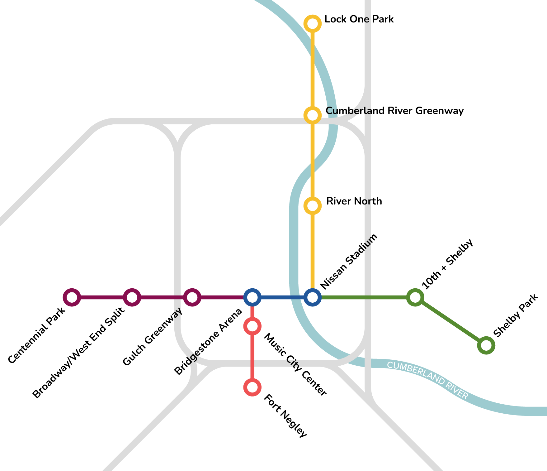
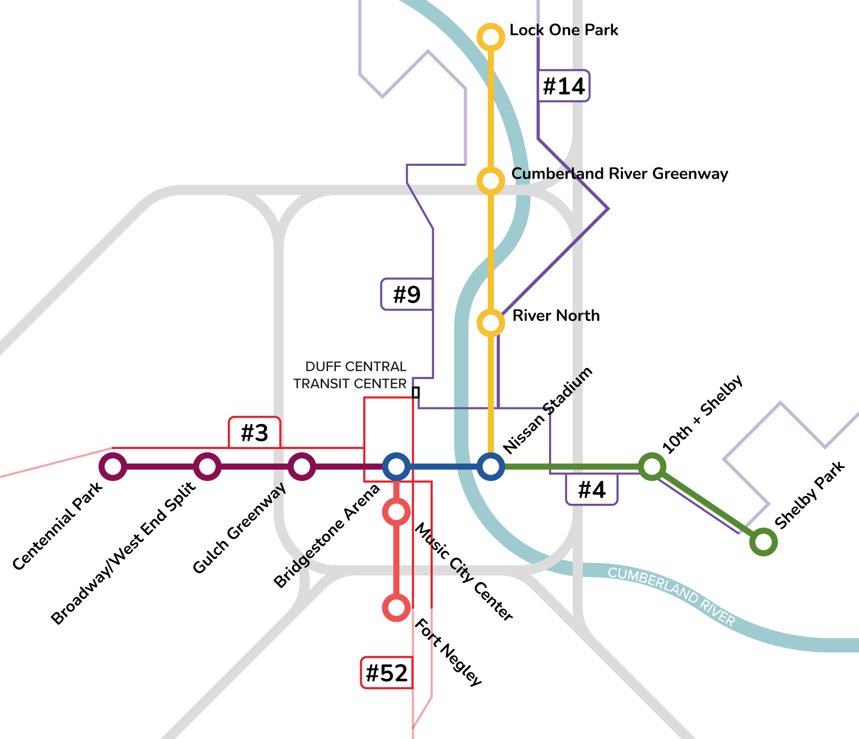
Station management requires dedicated personnel. Every gondola stop requires a physical terminal building, typically employing two to six workers on site, including station attendants, mechanics, and operational supervisors. In the Music City Skyway Plan, there are 13 proposed stations that could range from 25 – 100 employees.
Speed and routing also operate under physical boundaries. Operating speeds peak around 16 mph, which makes gondolas highly competitive in dense, congested urban cores but less suited for long-distance regional commuting. Because gondola cables run in straight lines between bullwheels, any turn or directional change requires constructing a physical intermediate station. While continuous boarding offers steady throughput, gondolas hit a fixed capacity threshold if passenger demand spikes beyond cabin design limits.
Finally, system maintenance requires built-in transit redundancy. Replacing a main haul cable or conducting heavy structural maintenance requires temporarily closing that line. While cable replacements occur infrequently, major transit corridors require baseline redundancy—such as parallel WeGo Public Transit bus routes—to maintain service during scheduled maintenance outages.
Extremely high winds can also force safety shutdowns, although 3S tricable technology significantly raises the operational threshold compared to standard single-cable lines. Initial capital costs for towers, terminals, and land acquisition also represent a substantial municipal investment, though still lower per mile than light rail or subway tunnels.
Station Concepts
The proposed network centers on a multi-hub loop anchored by architecturally striking stations that serve as active civic hubs.
The East Bank Station situates riders near the new East Bank Boulevard, integrating directly with planned greenways, rapid transit lanes, and public plazas.
View looking south down the East Bank Blvd.
(Original rendering from Imagine East Bank, Design Center Photoshop collage overlay, Google Gemini: architectural watercolor overlay)
The Broadway Bridgestone Arena Station serves as a central transfer node near lower Broadway to absorb peak nightlife traffic.
View looking southwest toward the Bridgestone Plaza upgrades, with a gondola station at 6th and Broadway
(Original rendering from Broadway2030, Design Center Photoshop collage overlay, Google Gemini: architectural watercolor overlay)
The Music City Center Station offers direct access to convention facilities to reduce surface shuttle vehicle trips and can connect to Midtown, where there are many more hotel options. This image below shows the Broadway/West End Split Station:
View looking west toward the Broadway/West End Split with a gondola station
(Original image: Google Maps; Design Center Photoshop collage overlay; Google Gemini: architectural watercolor overlay)
Creating a connected city means embracing innovative mobility solutions that work with our existing urban fabric and topography. An aerial gondola system offers Nashville a quiet, high-capacity, battery-free climate solution capable of linking key employment hubs, historically underserved neighborhoods, and the lifeblood of our city: the Cumberland River.
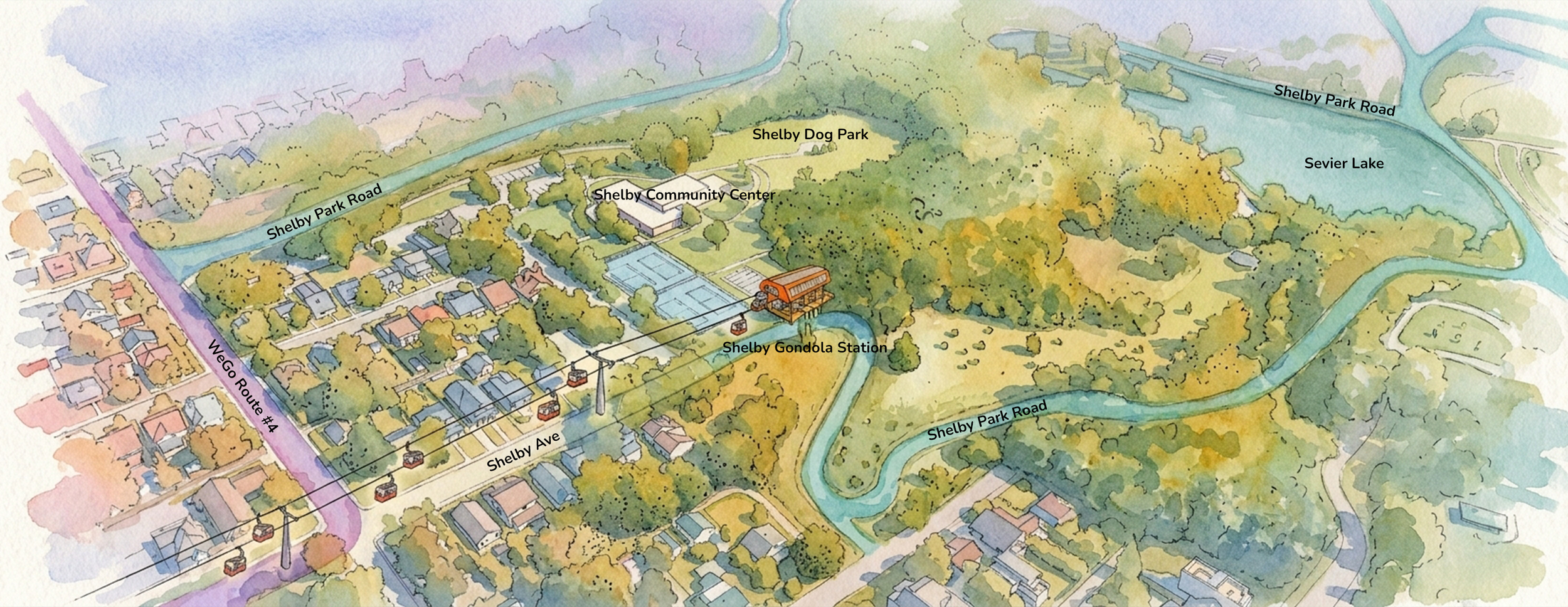
Aerial view looking north toward Shelby Park with a gondola station
(Original image: Google Maps; Design Center Photoshop collage overlay; Google Gemini: architectural watercolor overlay)