

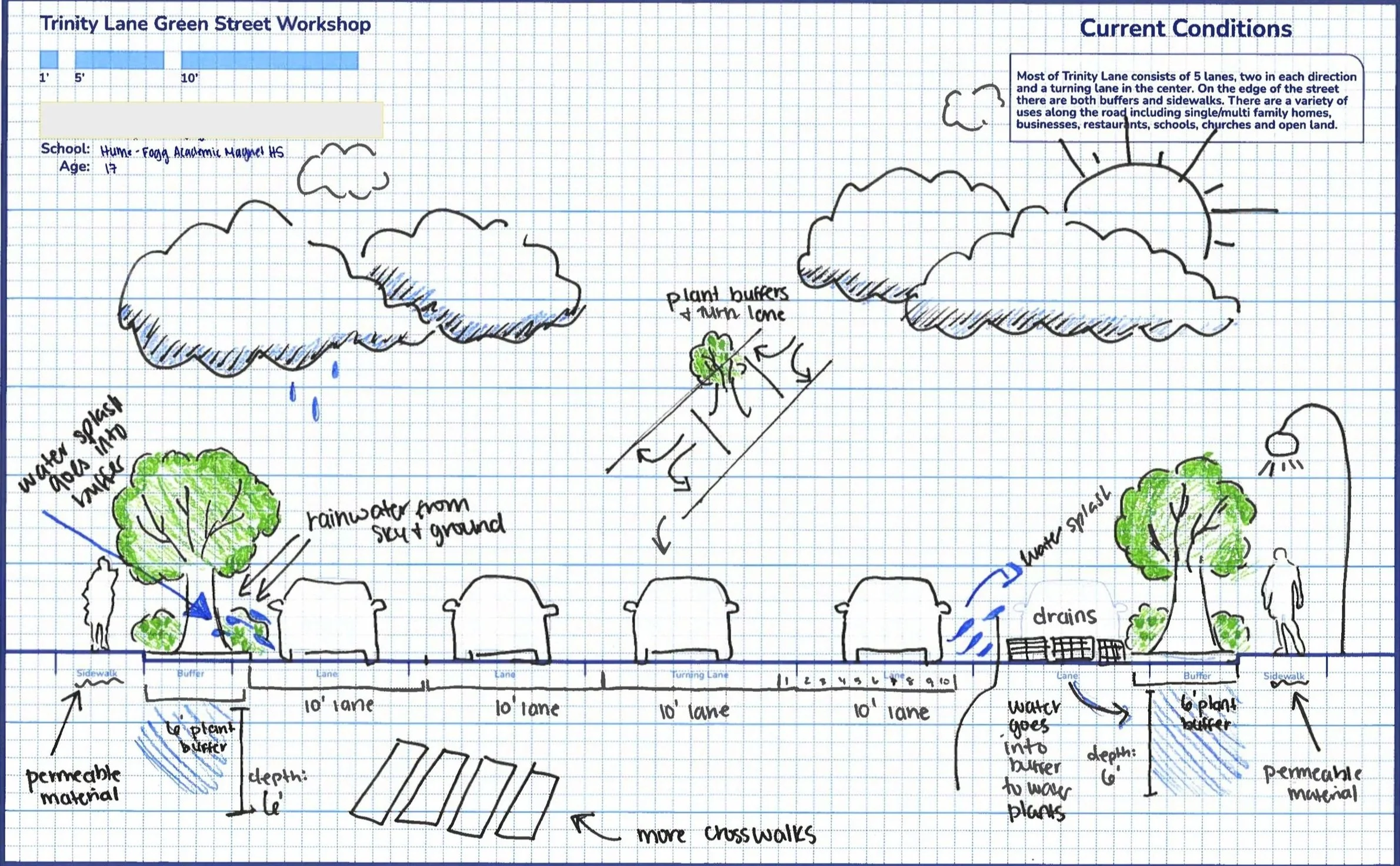
History of Lock One Park & Heaton Station
2 min read: This document was written by the Preservation Society of Nashville to provide historic context for the area surrounding Lock One Park. It aims to offer readers a deeper understanding of the significant events, landmarks, and cultural heritage that have shaped this neighborhood over time, highlighting its importance within the broader history of Nashville and preserving its legacy for future generations.
Lock One Park, located on the Cumberland River in East Nashville, is an area rich with historical significance that dates back to the late 18th century. Originally the site of Heaton's Station, the area has played a vital role in the early development of Nashville and the region. From its roots as a fortification and trading post to the later construction of Lock One, the history of this site is a testament to the area's growth and resilience.
Heaton's Station
Founded in 1780 by Amos Heaton, Heaton’s Station was one of the earliest settlements in Middle Tennessee, established as a fortified outpost during the frontier era. It was strategically located on a bluff along the Cumberland River, offering protection and a key access point to the river for early settlers.
Heaton’s Station as a Strategic Location: Positioned near the mouth of Well’s Mill Creek (now potentially associated with Page Branch), it provided an essential connection to the river for trade and defense against Native American groups.
Role in Early Nashville History: Heaton's Station became a critical hub for trade, agriculture, and defense. It served as a point of settlement for European-American pioneers and played a key role in the expansion of the Cumberland River Valley.
Transition to Heatonsburg: By 1783, the settlement became known as Heatonsburg, named after the Heaton family. It represented the area’s first established community in what would later become the vibrant city of Nashville.
Relocation and Legacy: In 1786, the Heaton family moved to a new settlement along Eaton Creek in Whites Creek, but the original site of Heaton’s Station remained significant as one of the foundational points in Nashville’s early history. A historical marker was placed at Lock One Road in 1968 to commemorate its importance.
Lock One and Its Impact

Photo courtesy of U.S. Army Corps of Engineers
Construction of Lock One (1894-1907): Lock One was part of a series of locks and dams constructed on the Cumberland River by the U.S. Army Corps of Engineers. The lock, completed in 1907, was instrumental in making the Cumberland River more navigable, aiding in trade and transportation for Nashville and the surrounding region.
Importance for River Commerce: Lock One served as a gateway for river traffic, facilitating the movement of goods and people along the Cumberland River. The lock played a crucial role in the development of Nashville as a key trading hub.
Engineering and Design: Built to handle the growing demands of river traffic, Lock One was an impressive feat of early 20th-century engineering. It is considered a significant example of river infrastructure from that era.
Decline and Transition: As modern river navigation systems replaced older infrastructure, Lock One was eventually decommissioned. However, its legacy as part of the city’s riverfront heritage continues to be felt today.
Key Historical Points for Park Revitalization


Photos by Veronica Foster
To enhance the revitalization of Lock One Park, the following key historical elements could be integrated into the project to celebrate its rich heritage:
Founding of Heaton’s Station: Highlight the origins of Heaton’s Station as a pioneer settlement. Interpretive signage could detail the life of early settlers like Amos Heaton, the station’s role in defense, and its connection to Nashville’s expansion.
Strategic Location of Well’s Mill Creek: Incorporate the historical significance of Well’s Mill Creek (potentially Page Branch) as a waterway for early trade and defense. This could be represented through maps or murals showing early routes and settlements along the river.
Historical Marker and Preservation of Heatonsburg: Utilize the existing historical marker at Lock One Road as a focal point. Revitalization efforts could restore and enhance this marker while expanding it to include more information about Heatonsburg, Heatons Station, and its role in the growth of Nashville.
River Trade and Lock One’s Role in Commerce: Develop interpretive panels or exhibits that highlight the history of Lock One and its role in river trade. This could include photographs, maps, and interactive elements showing the lock in operation and its impact on Nashville’s development as a major commercial city.
Public Engagement and Education: Organize public programs, walking tours, and educational initiatives that tie the historical significance of the site to its present-day revitalization. Partner with local historians, preservationists, and educators to create engaging content for visitors.
Historic Preservation in Design: Incorporate elements of historic architecture or engineering design inspired by the lock and station into the park's physical layout. This could include reintroducing historical architectural features like a replica lock or an old trading post for educational purposes.
Learn More:

Resources & References
Heaton's Station Historical Marker – The Historical Marker Database: [https://www.hmdb.org/m.asp?m=147765](https://www.hmdb.org/m.asp?m=147765)
Nashville Historical Newsletter – Eaton's Station: [https://nashvillehistoricalnewsletter.com/tag/eatons-station/](https://nashvillehistoricalnewsletter.com/tag/eatons-station/)
Metro Historical Commission – Historical Markers Program: [https://www.nashville.gov/departments/historic-preservation/programs/historical-markers](https://www.nashville.gov/departments/historic-preservation/programs/historical-markers)
Nashville.gov – Parks and Recreation: [https://www.nashville.gov/departments/parks/parks](https://www.nashville.gov/departments/parks/parks)
U.S. Army Corps of Engineers – Nashville District: [https://www.lrn.usace.army.mil/Library/Maps-and-Charts/](https://www.lrn.usace.army.mil/Library/Maps-and-Charts/)